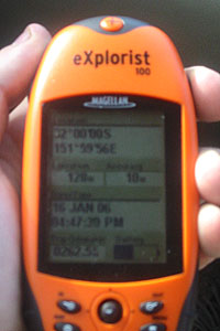
On the face of it the assignment doesn't sound too hard, but when you get down to the nitty gritty it is certainly more of a challenge. My just completed road trip north proved to be the perfect time to give it a go. I had all the tools; some wheels to get around, a map, and my Magellan Explorist 100 handheld GPS.
Using these tools the task was that I just then had to get to any point where the GPS tells me that I am at a convergence of a whole degree of latitude and longitude, i.e. with whole numbers for the degrees and only zeros for the minutes and seconds. Now after tripping across a state and a half I can safely say I have managed to get up close to two of them.
Before setting off on my trip I examined a NSW map and picked out any likely points on main roads that could easily be got to, and obviously on the way to where I was going. Luckily there were a few.
The trip north wasn't my main focus, despite noticing a couple of times that I wasn't very far away from a point I didn't bother to go and stop. It was a bit like "oh look I am only a couple of minutes away ... ahh it is behind me now .. forget it, let's keep going".
But on the trip back I had already highlighted a couple of spots and was keen to get to them. The first one (28° South and 152° East) was still inside Queensland south of Toowoomba, near the township of Allora on the New England Highway (for anyone reading this who knows Australian geography very well).
With me driving we approached it while passing through farmland. My mum in the passenger seat (who thought I was a bit mad, but got in on it) was holding the GPS and counting down to the zeros. The line for 28 degrees south came but we still had a few seconds to go for the 152 East. I spotted a side road up ahead heading that way and so we turned up it.
Now on the side road we came to the full line of longitude, 152, and stopped, the 28 south line of latitude was 20 seconds away to the north. I got out of the car and with my mum's "watch for the snakes" advice jumped over a barb wire fence and into a paddock. I was only about a hundred metres from the spot, before I thought, bugger it and just took a photo of the location from a distance and the GPS to say I was near to it.
There was a farm house and a ute in a neighboring paddock and I am sure those cranky Queenslanders don't take kindly to strangers ("git tha gun Ma, it's shootin' time"), so I hightailed it back to the car and took off.
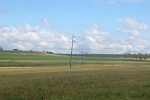
Underneath the power poles somewhere is the spot

Only 16 seconds away
Further along the track, many hours later (ok over 8 to be precise .. it was a long day of travelling) we came to my next proposed location. We were now back in my home state of New South Wales and actually back in the Hunter Valley, and there was another spot to hit (32° South and 152° East) near the township of Gloucester.
We headed on the road out of town, this time with mum behind the wheel and with the GPS in my hand I watched the digits count along. We crossed over the latitude line and swung around on the road before we realised that weren't going to be able to get to it from this road. On the side was a lookout so we pulled in there.
From the lookout I could see another road down below which we had passed the turnoff to, so I jumped back in the car and headed along it slowly. Closing in on the spot I realised it was just off the road near a house so we drove up a tad further to see if anyone was home and then saw some cars and kids on bikes.
Turning around we headed as close as we could to the location, with-in a couple of seconds or about 50 metres away and I snapped a picture from the safety of the car. In hindsight I should have donned the fluro safety vest which was in the back of the car and strutted over to the spot looking like I knew what I was doing, i.e. being a surveyor, but instead I am ashamed to say I took off without a little bit of trespassing.
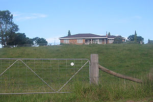
The spot, in paddock below the house
I was actually closer, but took this shot as the car was taking off so lost a little ground, and the shot was blurred
Later telling the news of my success to the original assignor of the task, I was informed that this is actually quite a hobby for some people. Not unlike the Geocaching thing (see previous post) I have now stumbled onto another rather nerdy thing people are doing with GPSs. There is a complete website set-up devoted just to this 'project' of reaching these points of 'confluence', as they are called, and the website goes along with catchy name of the Degree Confluence Project.
Unfortunately my two points, being rather easy to get to, have been hit before already, quite a few years ago (the write up for 28°S 152°E is here and 32°S 152°E here). Though it seems either my GPS is wrong or the guy who did the write up for the latter ones is. A close look at his photos seems to show he is on the other side of the road about 100 metres away from where I was.
One thought that I have now had after looking at this website, is that I find it refreshing that this project shows just how much of the world is off the beaten track. If you were one who was keen to get around and notch up a few of the locations you would see some very different places. I am also now a bit miffed that I didn't know about this while I was in PNG, I could have least tried to double the number of points that are hit there, from the 1 currently.
No comments:
Post a Comment